Word: Cartography
From: Greek chartis = map, and graphein = write
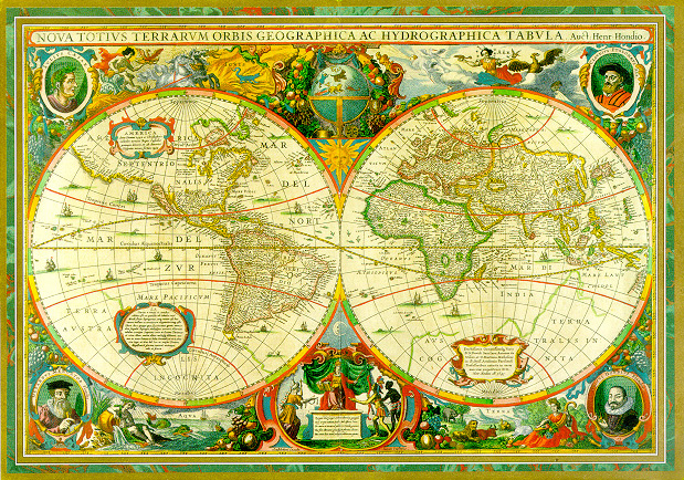 |
| From Mercator and Hondius' Novus Atlas, mid-17th century |
[The 17th century is] described as the Golden Age of map-making.
-Diedrick Wildeman
One of the lads, the Captain's player, just came back from travelling, and he brought back KLM's in-flight magazine, the Holland Herald (HH). The relevance here is an article about cartography in the 17th century, with a (hardly surprising) focus on the illustrious Dutch map-making tradition.
The reason for the player's, and also my own, interest in the topic is of course that the Netherlands of the 1600's is the chief source of reference-material for the Wezellian Syndicate of the Book of Worlds. That and our common love of maps. And so it is that this HR comes to deal with that very topic. I'll draw upon Andy Round's Secrets of the map-makers article in HH's September 2010 edition, as well as the omni-potent and all-knowing internets to shed some light on this topic. And of course I'll ground this in the world of Argos.
In the 17th century, the world was still a confoundingly large and mysterious place. White areas on the maps abounded, and even for known regions the maps didn't necessarily match the terrain. Still, the available maps were all anyone had. The era was also a time of increased exploration and trade -- the two being closely related.
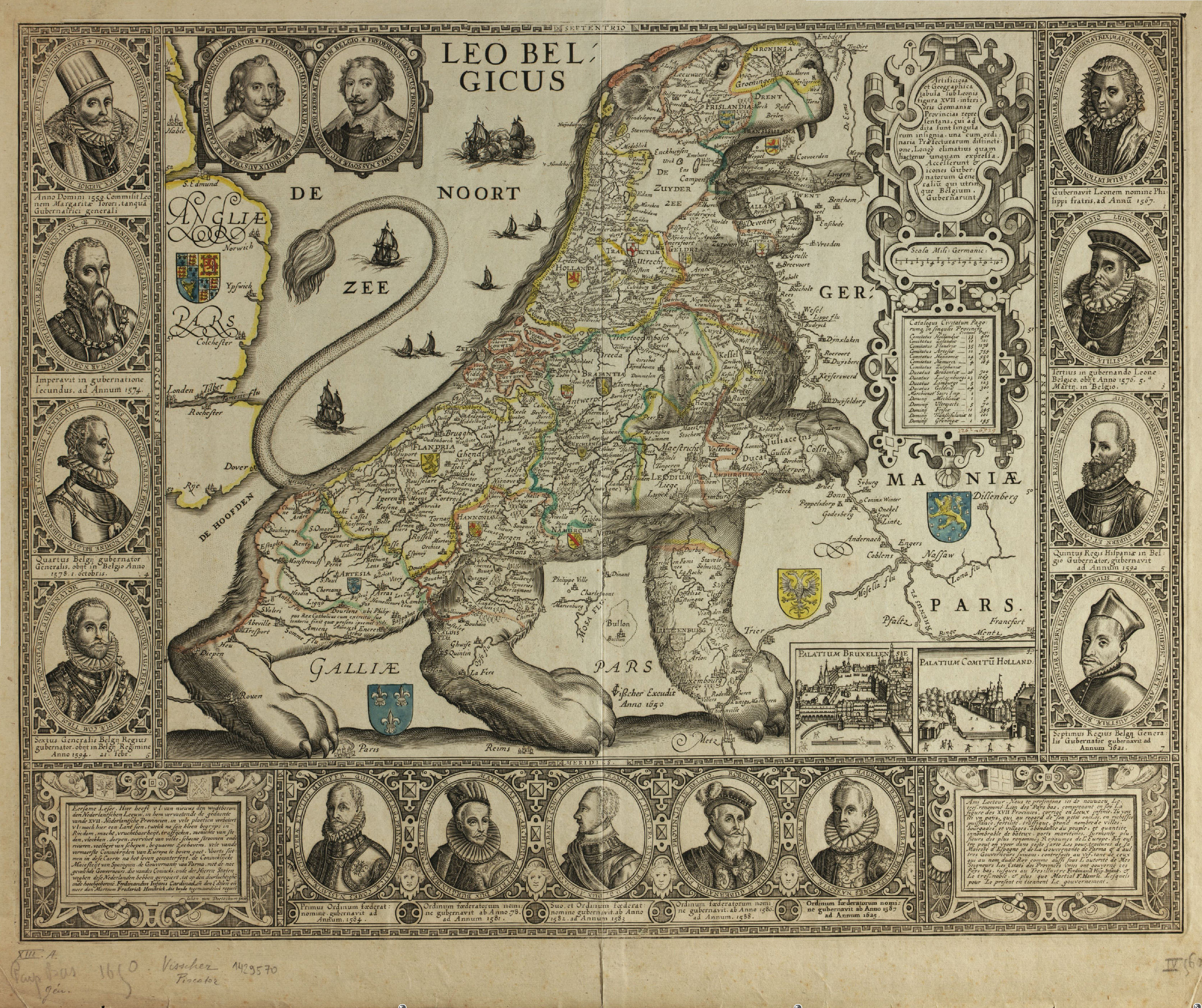 |
| Leo Belgicus, a popular rendering of the Netherlands. The Lion was drawn facing different directions, according to where the most prominent enemy lay. |
The HH article discusses the two major seafaring nations' different approaches on the availability of maps, or if you will, information. The Dutch Golden Age is usually said to span the century, and coincides with the rise of mercantilism. The beginning of the century also saw the formation of the Dutch East India Company (VOC), the first multi-national company ever, and also the first to issue stock. As a point of interest, it can also be called the world's first true megacorportion (Cyberpunk 2020 anyone?), but that's neither here or there. The VOC was most important in fuelling the Dutch economy, and for about 200 years it dominated European trade with the Orient.
 |
| Spanish Armada leaving off the Galician coast, 1588 |
Spain, on the other hand, was at this time a proper empire, ruled by the crown and a powerful nobility. Its overseas acquisitions were initially quite a disappointment, but in the 1520's that changed. Vast deposits of silver were found in Mexico. Eventually this led to the downfall, and bankruptcy of the Spanish Crown, as the almost exclusive import of precious metals caused a massive inflation, as well as the increased dominance of a feudal aristocracy. "The silver and gold whose circulation helped facilitate the economic and social revolutions in the Low Countries, France and England and other parts of Europe helped stifle them in Spain," Wikipedia.
To conclude this part of the history-lesson, other nations were of course involved, but they didn't get in the game properly yet, arguably due to all manner of domestic or neighbourly squabbles.
 |
| The North Sea, 1573 |
Now back to maps. In Spain, the maps of the colonies, and thus the world, were hand-drawn affairs, and kept under lock and key by the Crown. Smuggling maps out of the realm was considered an act of espionage, and was carried a death-sentence. Round gives a brilliant example of the value of this approach, in 1628 the Dutch captured one of the legendary Spanish Silver Trains, the crown was left on the verge of bankruptcy for a year.
The Dutch on the other hand had a different approach. Having access to the best engravers and printing presses of their age, and also a most efficient trade network, they opted for the sharing of information as the best way of expanding on their knowledge. Still expensive (an atlas could cost about as much as a present day second home, according to Round), it was still well within reach for an aspiring merchant house. Another factor is that the leading cartographers of the time happened to be Dutch.
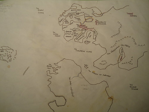
Eria and surrounding regions
Cartography on Argos.
While there are many superficial similarities between 17th century Europe and Eria at the end of the Third Age, there are a some major differences. Chief of the latter is that while Europe had in earnest started to reach out into the world for resources, Eria has not fully come to need external resources yet. At the dawn of the Third Age, a population greatly diminished by generations of war, both with each other and with the elves, now held a continent rich on natural resources.
For most of that age, no realm or nation needed much more than could be found on the Erian continent. Once the need outgrew the local supplies, the vast Northern Regions, or the ancient colonies on the Dark Continent, were sufficient to meet the needs of the growing realms of man. Combined with trade with the rich Waymar Islands in the West, and with the vast Caliphate in the East, the need for global exploration never truly arose.
Another factor in this is that the Royal Guild of Argonauts held a de facto monopoly on true navigation on the high seas. Limited charts, routes, or even guiding of convoys across the Outer Ocean were provided by the guild. Additionally, even in this Dark Age of Magic, certain pseudo-arcane techniques and rudimentary goetic instruments were available to navigators. This reliability on the supernatural, and of course the dangers of crossing the dark depths of the oceans, meant that naval exploration were regarded as closely affiliated with the dark arts, and thus regarded as dangerous at best, and a sure path to corruption at worst. Most Erian nations still regard the high-risk, high-profit naval trade as a most ignoble business.

I am very glad to have followed my nose to your lovely web home. I am finding a great number of beautiful and enriching treasures here.
ReplyDeleteI adore these maps.
And a warm, if belated welcome to you! I'm glad you like the stuff I've got lying around here. Please feel free to poke around, and don't hesitate to ask if you should have a question.
ReplyDelete